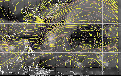
These are shear patterns over pacific ocean in 12Z 03 May and lastest one, 18Z 05May
In 12Z 03May, shear strength is about 15kts making CHAN-HOM a clear shear cloud pattern. While in 18Z 05May, shear is about 5kts. CHAN-HOM is consolidate and intensity!
After moving along 112E longitude, CHAN-HOM tended to move away from Vietnam coastal area and it's forecast to strike Philippines in 08May.
 JTWC forecast from 18Z 05 May for CHAN-HOM
Data supplied by the US Navy and Air Force Joint Typhoon Warning Center suggest that the point of landfall will be near 15.9 N, 119.5 E. Chan-hom is expected to bring 1-minute maximum sustained winds to the region of around 74 km/h (46 mph). Wind gusts in the area may be considerably higher.


No comments:
Post a Comment